
Marine Institute releases new seabed geomorphology map. The Marine Institute has released a new high resolution geomorphology map on the Irish Marine Atlas for most of the Irish continental shelf […]
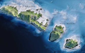
INFOMAR concludes Blue Scale Map Series with the Aran Islands and release of all 18 maps as Gaeilge. Ireland’s national seabed mapping programme, INFOMAR (Integrated Mapping for the Sustainable Development […]
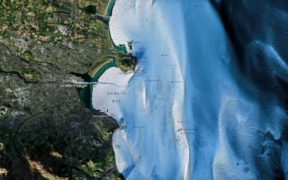
New INFOMAR Blue Scale Map shows Dublin Bay in stunning detail. Explore the depths of Dublin Bay, from Killiney to Howth, in remarkable detail thanks to a new series of […]

Latest INFOMAR Blue Scale Maps show Wexford coastline in stunning detail. See the iconic Wexford Coastline, from Hook Head to Carnsore Point, in remarkable detail thanks to a new series […]
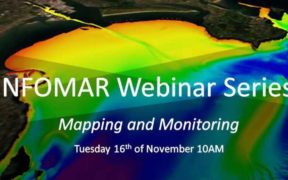
Invitation to INFOMAR Webinar Series. INFOMAR is delighted to announce the second in our series of online webinars, which provide their stakeholders with programme updates while detailing how INFOMAR products […]

INFOMAR laying foundation for understanding our ocean resources and growing out ocean economy. Ireland through its national seabed mapping programme, INFOMAR has achieved global recognition for its endeavour to systematically […]

Argo float deployed in Atlantic by Galway family. Marine Institute Argo Float was deployed in December 2019 en route from Cape Verde Islands to French Guiana by the Quinlan-Owens family […]


Fish Focus is an online communications, marketing, news and information platform offering a wide range of services for the seafood sector covering all aspects of aquaculture, commercial fishing, seafood processing and the route to market. Follow us on social media platforms for Fish Focus, Aquaculture Focus and Seafood Focus.


